AIS/Track Server is a Web Map Server (WMS) application that enables real-time tracking of, for example, ship movements. This type of application provides valuable information for various purposes, including maritime surveillance, security, and logistics. Vessel tracking applications are commonly used by maritime authorities and organizations to monitor ship traffic in maritime areas, ensuring safe navigation, enforcing laws and regulations, and monitoring potential threats such as piracy or illegal fishing. In emergency situations, like natural disasters or sea rescue operations, a vessel tracking application can assist rescue teams in locating and coordinating their efforts.
The software was initially developed to track vessels based on Automatic Identification System (AIS) messages transmitted by vessels to land-based base stations or captured by satellites. Later, the software was further enhanced to support various message formats and is now used, among others, by the Joint Rescue Coordination Centres in Norway to display positions of both vessels and helicopters as map layers in the crisis management system SARA (Search And Rescue Application).
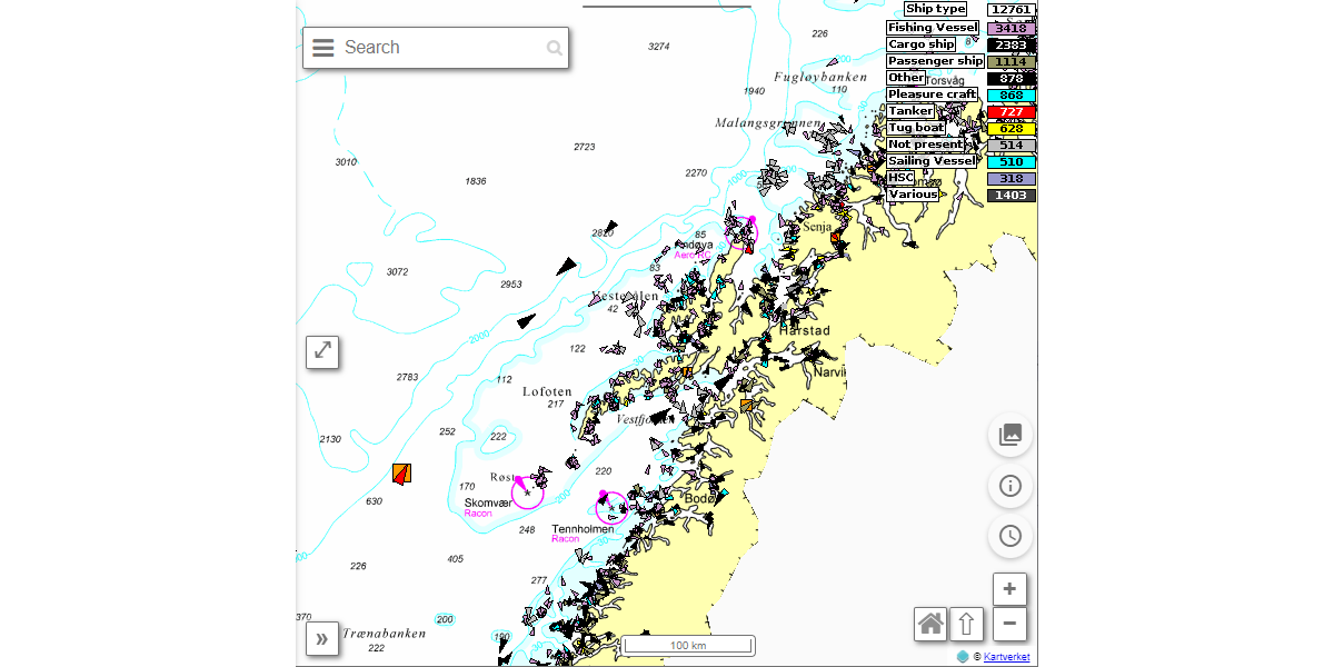
AIS/Track Server also includes a map client that can display multiple map layers in addition to the map layer from its own WMS server.
Users can filter and search for all available information in AIS messages. Each user can save their own filters for viewing map images and creating lists of vessel information in various formats. Such lists can, for example, be used in SARA to display information about all vessels in an area where a rescue operation is taking place.
The development of AIS/Track Server software began in 2004 in collaboration with entities such as the Norwegian Coastal Administration.
What is WMS?
A WMS application is a software component used to deliver map data to client applications over the internet. It is a standard defined by the Open Geospatial Consortium (OGC). WMS applications provide an efficient way to share and visualize geographic information on the web. They function by receiving requests from the client, which can be a web browser, a GIS (Geographic Information System) software, or another application. These requests may ask for map images with specific parameters, such as map extent, resolution, and layer selection. Layer selection could, for example, be a specific vessel type or vessels traveling at a certain speed. Subsequently, a map image is generated in accordance with the client's request and sent back to the client in a standard format, typically in the form of a PNG or JPEG file. This allows the client application to display the map to the user.
What is AIS?
AIS, which stands for Automatic Identification System, is a system used in maritime transport to enhance vessel safety and streamline the monitoring and control of ship traffic. AIS was initially developed as part of the International Maritime Organization's (IMO) efforts to reduce collisions and accidents at sea. The system operates by transmitting and receiving radio messages containing vital information about a vessel, including its identification number, position, course, speed, and other relevant details. AIS data enables ships to detect and identify other vessels in their vicinity, allowing them to take necessary actions to avoid collisions. Furthermore, AIS data also provide land-based authorities and service providers with the ability to monitor real-time ship traffic, enhance search and rescue operations, and regulate ship movements for safety and compliance. AIS has become a crucial tool for improving maritime safety and efficiency in international shipping.